Convert Vertical Datums
Vertical Datums represent a surface of zero elevation to which heights of various points are referenced. Working with multiple datums is similar to working with various units. For example, one could state the length of piece of paper is 1 foot or 12 inches.
- NGVD29-ft – The Sea Level Datum of 1929 was named the National Geodetic Vertical Datum of 1929 on May 10, 1973. The datum is defined by the observed heights of mean sea level at the 26 tide gauges and by the set of elevations of all bench marks resulting from the adjustment. This vertical datum was replaced by the NAVD88 datum and is not typically seen in floodplain mapping efforts these days.
- NAVD88-ft – The North American Vertical Datum of 1988 (NAVD 88) is the vertical control datum established in 1991 by the minimum-constraint adjustment of the Canadian-Mexican-United States leveling observations. In 1993 NAVD 88 was affirmed as the official vertical datum in the National Spatial Reference System (NSRS). The NAVD88 datum is currently used in elevation studies and floodplain mapping efforts.
Conversion Form
Fill out the form below to generate the x, y coordinates needed for the NGS Website. The external site tool will ask for a few other parameters, see instructions below form.
NGS Website Instructions
There are several sections that need to be configured to convert a vertical datum with the NGS Coordinate Conversion and Transformation Tool (NCAT). The following sections will help define the parameters for a typical vertical datum conversion between the NGVD29 and NAVD88 datums.
Configure the radio buttons based on the following selections:
- Select Horizontal+height for Convert/Transform from
- Select Geodetic lat-long for Select the type of horizontal coordinate
- Select Orthometric for Select a height
Next, copy and paste the x, y coordinates from the above form into the Lat Lon input (Enter lat-lon in decimal degrees). The copied coordinates are in decimal degrees. You can also use the degrees-minutes-seconds format if needed; there are many ways to configure the NGS tool.
Select the appropriate input/output reference frames. Typically, we refer to these as the horizontal datum. For Florida, we can select the NAD83(2011) horizontal datum option for both the input and output reference frame.
Enter an orthometric height in the next input field. Note: this tool utilizes units of meters not feet. It will be important to convert the final datum conversion value to feet in the final step. Using a value of 1 m is a good way to get a sense for how the elevation is changing from one datum to another.
Use the drop downs to select the input and output vertical datums. For this example, we will be converting 1 meter from NGVD29 to NAVD88. Leave the SPC Zone to default.
NGS Input Example
The screenshot below shows an example input form for the NGS datum conversion tool.

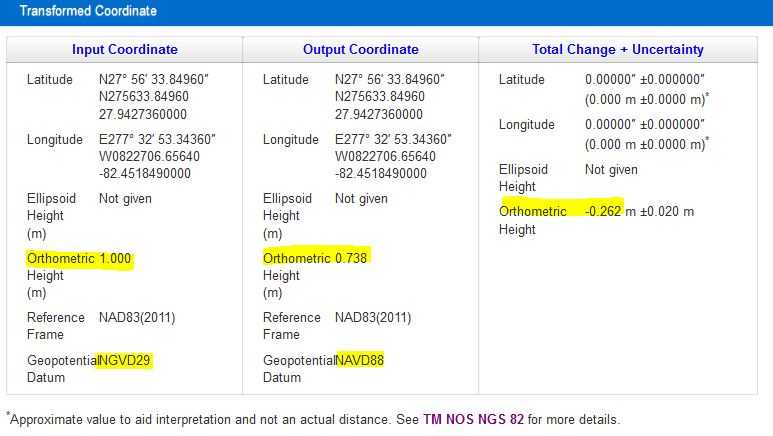
Output Information
The screenshot below shows the output information from the NGS tool. We can see the input and output coordinates, orthometric heights, vertical datums and the Total Change observed during the conversion. In this example, an area near downtown Tampa, FL would use a conversion factor (going from NGVD29 to NAVD88) of around -0.262 m or -0.86 ft (multiply meters by 3.281 to get to feet). As another example, if the NGVD29-ft elevation was defined as 50.0 ft, the NAVD88-ft value would be 50.0 ft - 0.86 ft = 49.14 ft.
ABOUT US
A Tampa Bay area based company providing engineering and insurance consulting solutions for flood zone properties across the state of Florida.OUR MISSION
To give the people of Florida the power to make informed decisions by organizing Florida’s latest flood data and making it readily available to all its home buyers.100% RISK FREE
Our complimentary reviews ensure you get the best information possible, risk free.© 2023 All rights reserved